| Focus on aquatic habitat survey evaluation and mapping | |||||||||
| MX provides hydroacoustic survey solutions to customers in the fields of aquatic habitat survey and water ecological research around the world.It adopts an integrated design, which is lighter and more portable than ordinary echo detectors. It integrates multiple functions and has a built-in differential GPS sensor, which can meet the three functions of subsided vegetation survey, base classification, and water depth measurement at the same time.BioSonics Visual Habitat data processing software can help users download maps with one click. Through analysis, the results of the survey area's tracks, water depth, submerged vegetation, and basement types can be clearly marked on the map, and can be generated by interpolation.Distribution map.At the same time, analyzing and exporting data can support importing software such as ArcGIS for advanced drawing. | |||||||||
| Function | 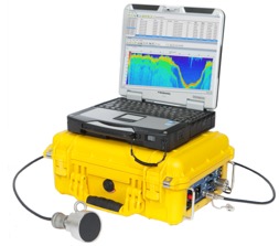 | ||||||||
ComeSurvey and Assessment of Submerged Vegetation—Spatial Distribution, Coverage, Canopy Height ComeClassification of water base material—Measure the distribution of sand, sludge and rocks ComeWater depth measurement, bottom drawing ComeDownload the map with one click and generate the distribution map | |||||||||
| Technical Indicators | 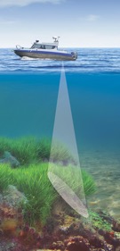 | ||||||||
Come ComePower supply requirements: 12-18V DC or 85-264V AC ComeEmission source level: 213dB re 1uPa ComePulse length: 0.4ms ComeTransmission frequency: 5Hz ComeDistance resolution: 1.7cm ComeAccuracy: 1.7cm±0.2% of depth ComeDepth of detection: 0-100m ComeInstrument operating temperature: 0-50℃ | |||||||||
| Size and weight | |||||||||
ComeHost: 37cm×26cm×15cm, 5.4kg ComeTransducer: 8.4cm (height) × 4.3cm (diameter), 1.36kg | |||||||||
| Transducer | |||||||||
ComeSingle frequency—200kHz ComeBeam angle: 8.5-9°, tapered ComeHigh-strength stainless steel shell | |||||||||
| bio sonics visual habitatData analysis software | |||||||||
BioSonics Visual Habitat is a complete set of analysis tools, and its analysis features include: ComeSubmerged vegetation (SAV)—Spatial distribution, crown cover height, percentage coverage ComeWater depth measurement – draw high-precision maps and depth maps ComeClassification of water base material—delineate the distribution of different types of base material such as rocks, sand, and sludge ComeQuickly call and download maps from Google, Bing, Open Street and other map servers ComeThe output file format is CSV (data table) or KML (graphics) ComeRapidly generate a distribution map of target objects, showing the path section, the distribution of water depth, base material type and submerged vegetation | |||||||||
| A color echo diagram of the survey section, showing information such as water depth, plant distribution, and underwater terrain. | 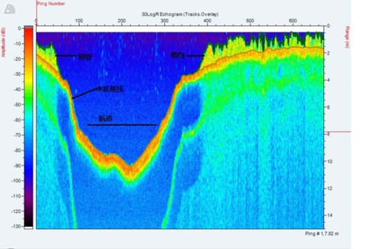 | ||||||||
| The track map is drawn based on the coordinate position measured by the built-in DGPS sensor. It can load the user's own map, or you can easily download third-party maps with one click, such as Google, Bing, Open Street, etc. | 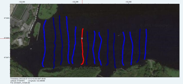 | ||||||||
| Water depth drawing, the water depth of the survey section can be drawn on a map.Different colors represent different water depths, and users can define their preferred colors to represent water depths. | 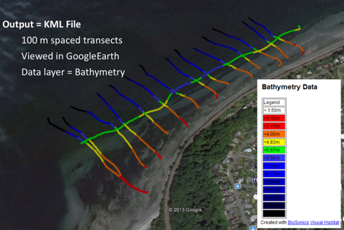 | ||||||||
| Submerged vegetation mapping allows the plant height and coverage distribution of the survey section to be drawn on the map.User-defined colors and gradients to represent plant height and coverage.The middle parts of all sections in the left figure are white, indicating no vegetation distribution. | 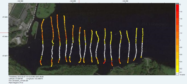 | ||||||||
| BioSonics Visual Habitat software can use trilinear interpolation, inverse distance weighted interpolation and ordinary Krieg interpolation to generate a two-dimensional distribution map, and can automatically calculate rasterized statistical results: area, water volume, maximum/minimum/average water depthwait. |  | ||||||||
MXEcho detector and remote-controlled unmanned ship | 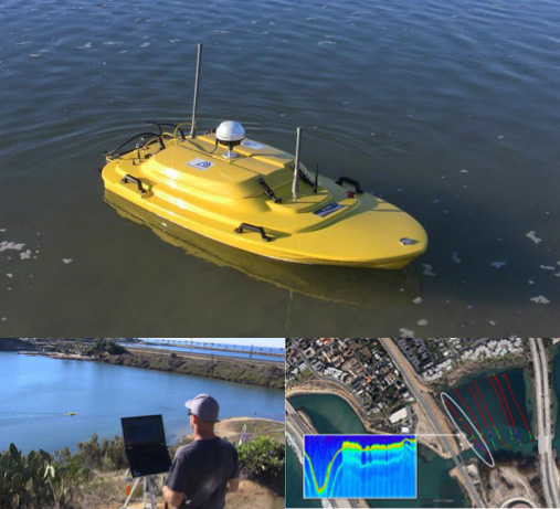 | ||||||||
| The Z-Boat 1800MX water survey system was jointly developed by OCEANSCIENCE and BioSonics. It uses OCEANSCIENCE's wireless remote control tugboat as a mobile platform and data transmission platform, and uses BioSonics' MX echo detector as a data acquisition subject, and uses 200KHz ultrasonic echo detector.Acoustic signals of water bodies are collected to form color echo maps for water bodies terrain measurement, base material classification survey, water depth measurement and submerged plant survey.The Z-Boat1800 is an ultra-small survey ship that is convenient to carry and can be wirelessly controlled.Especially suitable for use in remote areas where boats cannot be rented and in shallow water where boats cannot be sailed. | |||||||||
| Origin:BioSonics in the United States | |||||||||