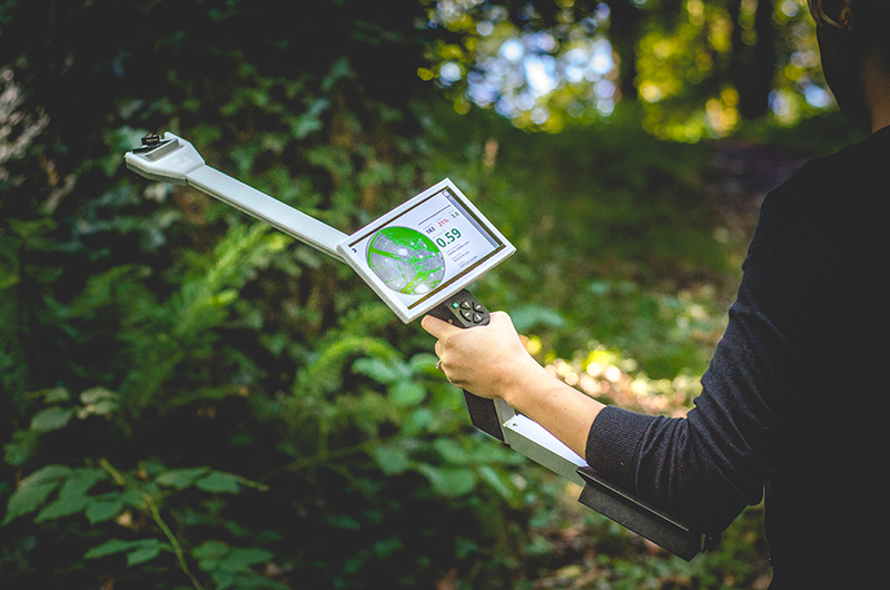
Plant canopy analyzer uses fisheye lenses and CCD image sensors to acquire plant canopy images.Through professional software analysis, the leaf area index (LAI) of the plant canopy and other canopy parameters were obtained; the automatic horizontal digital camera obtained the 150° canopy image, and 24 PAR sensors on the handle measured the photosynthetic effective radiation and calculated the light spot.Image measurement of plant canopy, only obtainonceCanopy image is enough, which simplifies the traditional energy method to be fixed in one dayrepeatedlyThe measurement is complicated; at the same time, you can avoid obstacles and select the appropriate measurement point.
Main functions
ØMeasure the canopy leaf area index (LAI), photosynthetic effective radiation value, and calculate the solar spot
ØAdjustable lens focus is suitable for canopy measurements at different heights, available from low plants to trees
ØThe lens is automatically horizontal, and it is imaged at one time. The measurement is not affected by weather or light, and there is no need for blank sky comparison measurement.
ØNo reference measurements are required on the top of the canopy
ØAcquire color images of plant canopy on site and display and store them directly. The powerful canopy analysis software function can manually adjust thresholds and automatically adjust thresholds (OTSU), and evaluate the solar direct radiation transmission coefficient in the canopy on site or LAI analysis gaps.coefficient.
ØSoftware sets the zenith angle and azimuth angle
ØUsers can filter the sky and leaves through analysis software
ØEasy positioning through GPS and compass functions, and repeated measurements are performed at a fixed point during the plant growth season.
ØSoftware blocks and avoids useless images such as people, sky, etc. that affect image calculation results.
Measurement parameters
ØPlant canopy leaf area index (LAI)
ØAverage blade inclination angle (MLA)
ØTransmission Coefficient
ØExtinction Coefficient, Transmission Coefficient, Leaf Distribution
ØGPS Lock Information (GPS Lock)
ØSunflecks, Photosynthetic Effective Radiation (PAR)
Application areas
Widely apply agricultural science, forest science and plant structure analysis, study the plant leaf area index and production relationship, canopy index of forests, and the growth monitoring of crops and trees; the effective photosynthetic radiation intensity in the forest; the leaves of trees of different latitudesChanges in area index, the impact of environment on plant observation, measurement of canopy of field crops, forests and low plants
Main technical parameters
ØLens viewing angle: 150° wide-angle lens
ØCamera resolution: 8 million pixels,
ØInteractive interface: 7" touch screen, 6 buttons
ØMeasurement time: 0.5 s
ØCanopy division: 1 to 10 zenith angle; 1 to 10 azimuth angle
ØImage analysis: Canopy map can be adjusted, analyzed and edited
ØWorking environment: 5-50℃, 0-100% RH (no condensation)
ØOperating rod: 400mm
ØPAR sensors: 24
ØAdditional function: GPS data display
ØPower supply: > 6 hours
Purchase Guide
Handle, fisheye lenses, operating instructions, software and portable suitcase
Woodland measurement mode

Origin: CID, United States
References
Original data source: Google Scholar
1. Ziany N. Brandão & João H. Zonta (2016) Hemispherical photography to estimate biophysical variables of cotton, Revista Brasileira de Engenharia Agrícola e Ambiental, 10.1590/1807-1929
2. Jarrah Wills, John Herbohn, Maria Opelia Maranguit Moreno, Mayet S. Avela, Jennifer Firn, (2016) Next-generation tropical forests: reformation type affects recovery of species and functional diversity in a human-dominated landscape Authors, Journal of AppliedEcology 10.1111/1365-2664.12770
3. Long-Fei Chena, Zhi-Bin Hea, Xi Zhua, Jun Dua, Jun-Jun Yanga, Jing Lia (2016) Impacts of affordance on plant diversity, soil properties, and soil organic carbon storage in a semi-arid grassland ofnorthwestern China, CATENA 10.1016/j.catena.2016.07.009
4. Adil Enis Arslan, Esra Erten, Muhittin İnan (2016) Application of Geodetic Projections to Terrestrial Laser Scanning in Leaf Area Index calculation, Signal Processing and Communication Application Conference 10.1109/SIU.2016.7495900
5. Prahlad, V.C. (2016) Studies on Canopy Distribution, Stand Growth and Regeneration in Cedrus deodara (Roxb.) Loud Under Temperate Conditions of Himachal Pradesh, Thesis for the Dr. Y.S. Parmar University of Horticulture & Forestry, Solan
6.Junaid N. Khan; A. K. Jain; Vijay P. Singh, F.ASCE; R. Kumar; R. Sharda; and M. Siag (2016) Simulation of Mulch and No-Mulch Conditions for Various Soil Matric Potential Thresholds for Drip-Fertigated Guava (Psidium guajava L.) in the Semiarid Region of Northwest India Journal of Irrigation and Drainage Engineering10.1061/(ASCE)IR.1943-4774.0001047
7.Shi De-yang, Li Yan-hong, Zhang Ji-wang, Liu Peng, Zhao Bin, Dong Shu-ting (2016)Increased plant density and reduced N rate lead to more grain yield and higher resource utilization in summer maize,Journal of Integrative Agriculture 10.1016/S2095-3119(16)61355-2
8.Davi Rodrigo Rossatto, Everlon Cid Rigobelo (2016) Tree encroachment into savannas alters soil microbiological and chemical properties facilitating forest expansion, Journal of Forestry Research 10.1007/s11676-016-0219-0
9. Assal, T., Anderson, P., Sibold, J. (2016) Spatial and temporal trends of drought effects in a heterogeneous semi-arid forest ecosystem, Forest Ecology and Management, 365 (137-151). 10.1016/j.foreco.2016.01.017